Read Stonehenge a New Understanding Online
Authors: Mike Parker Pearson
Tags: #Social Science, #Archaeology
Stonehenge a New Understanding (9 page)

The interior of House 7 in the stone-built Neolithic village at Skara Brae, showing the stone dresser and central hearth.
Back in 1967, Geoff Wainwright directed a massive project at Durrington Walls, what was then the largest excavation undertaken in Britain. He had to deal with a 50-meter-wide strip driven right through the middle of this huge henge, in advance of a new road. In the henge ditch, under the henge bank, and in the holes for the posts of the two timber circles, Geoff’s team had found lots of pieces of pottery.
3
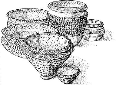
Peterborough Ware was a style of Middle Neolithic pottery used throughout most of Britain in 3400–2600 BCE.
This Neolithic pottery is decorated in a very distinctive style. It’s covered in patterns of grooves or incisions, and almost looks like an imitation of basketry. Styles of ancient pottery are always given names—archaeological shorthand that lets specialists talk about pottery without having to describe it every time they have a conversation. Pottery is often named after a “type site,” such as a widespread type of Neolithic pottery called Peterborough Ware. Sometimes it’s named after its shape, such as the Beaker pottery of the early Bronze Age. And sometimes it’s given the simplest name imaginable—the Neolithic pottery found at Durrington Walls has grooves, so it was called Grooved Ware.
4
Another linguistic quirk is that the clay of the pot is called its “fabric”—this has nothing to do with cloth.
The soft, black fabric of Grooved Ware looks to the untutored eye like coal or charcoal. Looking back, Colin realized that what he thought were tiny shards of Grooved Ware in those molehills at Durrington Walls were actually pieces of not-so-ancient coal or coke from Victorian steam-plowing. But he’d caught the archaeological bug. Not only did Colin have a passion for Grooved Ware, but he was also fascinated by the mysterious
people who used it—these are the people who built the henges and standing stones more than four thousand years ago. Working for Colin at Barnhouse, where the Neolithic inhabitants had also used Grooved Ware, I could see how he was revealing their everyday lives through his excavations of the remains of their houses.
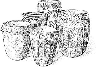
Grooved Ware was a style of Late Neolithic pottery used throughout Britain in 2800–2200 BCE, probably originating in Orkney around 3200 BCE. It is the style of pottery used at the Neolithic village of Durrington Walls.
If our project was going to get off the ground, we would have to do a lot of work at Durrington Walls, above all to find out whether it was linked to the River Avon by a ceremonial avenue, as predicted in our article published four years earlier. By huge luck, we were in the right place at the right time. Durrington Walls lies mainly on private land and everyone had heard that the farmer really wasn’t keen on archaeologists. As Colin and I made plans, however, we learnt that the land had been sold; we crossed our fingers and contacted the new farmers, Stan and Henry Rawlins. When we turned up to have a look at their field, they were a bit wary at first—just how much of their untouched pasture did we want to dig up?—but they let us get on with it. We explored the field, starting at an entrance through the henge bank and ditch, and then moving eastward down a slope toward the River Avon.
Few archaeologists had ever looked down by that part of the river. The steep bank between the river and the field was covered in brambles,
stinging nettles, and blackthorn but Colin and I could see that there was a large, deep gully leading down to the river from the east entrance of the henge. Was this the remains of an artificial incline constructed by Neolithic builders to provide access to the river?
We arranged a site meeting with staff of English Heritage, adjourning to the nearby Plume of Feathers at Shrewton to discuss the possibility of starting a project. Durrington Walls and its environs down to the river is scheduled as an ancient monument. This means that it’s protected by law and that any activity that affects it by breaking the ground surface requires consent from the Secretary of State for Culture, Media, and Sport. The minister makes her decision on the advice she receives from English Heritage, whose archaeologists must decide whether any proposal for an excavation on a scheduled ancient monument is acceptable. If they were unhappy with what we wanted to do at Durrington Walls, then the project would be a non-starter.
Unfolding maps and plans between the beer mats on a pub table, Colin and I outlined our ideas for a Stonehenge Riverside Project, to investigate the possibility that this stretch of the River Avon was a significant key to understanding the two henges—Durrington Walls and Stonehenge—as parts of a single complex. The feedback was positive. If we could raise enough money and resources to run a project to the best archaeological standards, then there was a chance that our project might actually happen. English Heritage certainly was not going to pay for the research but it could help with some of the geophysical survey, and would be prepared to recommend consent if it received a strong proposal.
The next summer, in 2003, we got started. With no money but helped by a team of local volunteers, we cleared the scrub on the slope down to the riverside so we could map the earthworks of the gully. We also brought in a soil specialist, Mike Allen, who has worked on chalklands for most of his professional career. His favorite bit of equipment is a gas-powered auger that drills thin cores of soil and chalk from deep below the ground. We hoped his machine would tell us whether the gully was indeed a prehistoric earthwork and whether there was any trace of a prehistoric road surface leading down to the river. At the same time, English Heritage’s geophysics team carried out a magnetometer survey across the field, looking for magnetic variations below ground that might reveal
the locations of buried features, such as pits and ditches—what archaeologists call “magnetic anomalies.”
The augering results were difficult to make sense of. There was indeed a filled-up gully leading to the river, but whether it was a buried roadway or just a natural valley was difficult to say. The geophysics had picked up evidence for a ditch running along one side of it but not the other. Otherwise there was not much showing outside the henge’s east entrance, apart from two highly magnetic areas.

A plan of Durrington Walls showing the bank of the River Avon (right), the avenue leading through the ditch and bank from the Southern Circle, the Western Enclosures (center left) and the positions of some of our trenches. Woodhenge is the much smaller monument at the bottom.
One of the people who joined us that week was Kate Welham, an archaeology lecturer at Bournemouth University who had finished her PhD at Sheffield University just a few years earlier. Her main research interest is in glass-making in the fifteenth to eighteenth centuries, so prehistory was not exactly her thing, but she came over to Durrington for
the day to help out. With a background in science, Kate had something Colin and I couldn’t provide: a thorough grasp of computing, GPS surveying, and geophysics. If this was going to be a big project, we would need someone with her abilities to organize the vast amounts of data that would be collected from survey and excavation, and to coordinate the various kinds of surveys. This was the first time Colin and Kate ever met—we spent the day getting absolutely soaked, and eventually left Kate surveying on her own in the rain while we huddled rather guiltily in the car. I don’t think Kate held it against us: She and Colin have since worked together on many survey projects from the Western Isles to Easter Island. That nasty wet afternoon in Wiltshire saw the birth of a good team.
Drying Kate out back at the pub that evening, we realized that even three of us would not be enough to direct a project of the size required. We worked out that we were going to need a team of experts, to draw on resources and expertise from many different institutions. There would have to be at least six of us. At Manchester University, Julian Thomas had recently been appointed as professor of archaeology. Julian was not only an expert in the Neolithic of Wessex and southern Britain
5
but had also worked with Colin years before, re-analyzing the results of Geoff Wainwright’s excavations at Durrington Walls.
Geoff had published his results very promptly in 1971.
6
His team had recovered large quantities of finds—animal bones, flint and bone tools, and pottery—from the topmost layers of soil (the “upper fills”) in the postholes of the long-vanished timber circle known as the Southern Circle. Geoff thought these were chance items that had been propped randomly against the posts, falling into the holes when the posts decayed. In 1984 Colin and Julian, still students at that time, had reinterpreted the patterns of deposition in the holes.
7
They found that the distribution of finds in the postholes was far from random. One pit might have lots of bone pins but no flint tools, for example, while another might be principally full of broken pots. They suggested that the items in each posthole had been selected—that they hadn’t ended up in the postholes by chance but were “structured deposits” put there as part of ritual activities within the decaying timber circle.
Julian was delighted to be asked to join the project. Like Colin, he had always harbored a secret wish to dig at Durrington Walls. The two of
them could bring university funding and equipment that would get the project afloat.
Chris Tilley, professor of material culture studies at University College, London, and one of my student contemporaries, also joined us. Chris had shaken the world of archaeology in the 1980s and 1990s with his radical theoretical approaches. Most recently, he had pioneered an approach to understanding prehistoric landscapes, known as phenomenology: This basically entails trying to experience moving through landscapes in the ways that prehistoric people would have used them.
8
Maps, plans, and geographical information systems (GIS) are all very well but, in Chris’s view, there is no substitute for learning about the Stonehenge landscape on the ground—walking the routes that ancient Britons walked and experiencing the views and vistas that they would have seen.
Modern roads and pathways, hedges, and fields completely disrupt our appreciation of how prehistoric people saw and experienced Stonehenge and the monuments around it. Chris wanted to explore the ways that the natural topography was used for approaching the monuments, by following the many small valleys, or coombes, that lead up from the river, by walking the routes of the Stonehenge Avenue and another long, thin earthen monument to its north, called the Greater Cursus, and by exploring the course of the River Avon. He appreciated that the Neolithic was essentially a riverine culture, in which streams and river valleys were the roads and motorways of their day, for both foot and boat travel.
Our other codirector was to be Josh Pollard, then newly appointed as a lecturer in archaeology at Bristol University and now a professor at Southampton University. Josh had excavated Neolithic sites across the Wessex chalklands and was just coming to the end of a project at Avebury.
9
Avebury is Britain’s second-greatest stone circle, set within a ditch and bank enclosing almost as big an area as Durrington Walls but with a much deeper ditch. Durrington Walls’ ditch is pretty impressive at 5.5 meters (18 feet) deep, but the Avebury ditch is a staggering 8 meters (26 feet) in depth.